

In the summer of 2012, I began a tenure-track position at the University of Northern British Columbia in the traditional territory of the Lhleidli T’enneh. This proved to be an interesting time for me, an early career environmental scholar of Métis and settler European ancestry, to arrive in the region. Protests and public hearings related to the Northern Gateway pipeline were at their peak, and Idle No More, a socioenvironmental Indigenous and allied resistance movement (Kino-nda-niimi Collective 2014), arose in the fall. Direct involvement with these activist initiatives and postsecondary teaching in related areas expanded my understanding of and engagement with news media. Building on previous experiences as an outdoor guide and environmental educator, in which I both used Western-style maps and spent time with Indigenous Elders on the land on a regular basis, I also began to consider the role of cartography in media representations of traditional and contemporary Indigenous relationships with land and water. These interrelated interests have persisted and led me to further inquiry, as discussed in this article.
The ongoing proliferation of petroleum infrastructure, resource extraction, and associated environmental degradation throughout Indigenous territories across Turtle Island / North America is well established. Such challenges are further compounded by social and health concerns related to gendered violence against Indigenous women and girls and the continued incursion of “man camps” near Indigenous communities (Awasis 2014; Weber, Geigle, and Barkdull 2014). The COVID-19 pandemic has further heightened health concerns in surrounding rural regions, where limited health-care facilities are already underequipped to deal with potential outbreaks (Indian Country Today 2020). These dynamics combine to create an interconnected web of socioecological disaster.
As indicated in the call for papers for the Disaster Media stream of Media+Environment, contemporary news media must be considered as both representative of and influential upon broader societal beliefs and understanding—they play an important role in curating public opinion on and understanding of such dynamics (Brady and Kelly 2017; Endres 2012; Gilbert et al. 2019). As Parks and Walker (2020) suggest, there is a pressing need for public news media that promote critical understanding, facilitates increased voice for and representation of marginalized peoples, and advocates for equitable relief from socioecological disaster in a spirit of social and environmental justice.
Journalistic maps are an arguably underscrutinized element of news media productions that hold considerable power to influence our understanding of cultural, political, and geographical relationships and hierarchies (Culcasi 2006; Novaes 2014). This is particularly true in Indigenous contexts due to the long-standing reciprocal relationships of Indigenous cultures with particular places (Cajete 1994).
In this article, I consider journalistic maps through a lens partially informed by the interrelated concepts of decolonization and Indigenization. Decolonization involves, most generally, the critical deconstruction and analysis of colonial systems (Smith 2013). Some scholars, such as Tuck and Yang (2012), also argue that a commitment to decolonization implies tangible actions and results such as “the repatriation of Indigenous land and lifeways” (p. 1). Indigenization denotes the incorporation of Indigenous cultural values, practices, and languages within a given societal or institutional context (Battiste 2016). In my experience with related Indigenous environmental education and research (Lowan-Trudeau 2015), decolonization and Indigenization must be considered and enacted in ongoing dialectical relation to each other. For example, avoiding the sociocritical elements inherent to decolonization in favor of Indigenization introduces the potential for further romanticization of Indigenous peoples and practices (Brady and Monani 2012; Willow 2010) without critical understanding of the impacts of colonization. Conversely, focusing solely on the critical aspects of decolonization without providing motivating examples of Indigenization can leave learners, Indigenous and non-Indigenous alike, bereft and uncertain of how to move forward.
Building on research in the fields of education and visual literacy, this article raises critical questions about cartographic representations. Educational scholar Elliot Eisner’s (2002) theory of the three curricula—the explicit, the implicit, and the null—is also germane to inquiries such as this that critically consider the informative societal role of news media. In a cartographic context, the explicit curriculum comprises the geographical, political, and cultural features explicitly included in a given map. The null is what is not shown at all through intention or ignorance. The implicit curricula are the lessons that are implied through the explicit and the null: what might be implied by the inclusion, for example, of highways and Western political boundaries but the exclusion of natural features such as rivers, lakes, and mountain ranges or Indigenous territories and place-names? I also draw upon Antonio López’s (2017) ecomedia visual literacy framework in this inquiry. Building upon Panofsky’s (1962) work in art history, López encourages us to consider the connections between the physical and structural elements of a given image, sociocultural codes that might be embedded within the imagery, and associated discourses.
Theoretically framing this inquiry through decolonization, Indigenization, Eisner’s (2002) three curricula, and López’s (2017) ecomedia visual literacy framework allows me to critically consider what is present as well as identify what is missing from journalistic maps of socioecological disasters in Indigenous contexts—visual representations that hold significant influence over the general public’s understanding of specific cases such as the Wet’suwet’en people’s resistance to the Coastal GasLink pipeline (CBC News 2020; Dhillon and Parrish 2019) described below as well as colonial geographic and cartographic paradigms and practices more generally.
Inspiring examples of Indigenous countermapping are also presented—cartographic counternarratives (Giroux et al. 1996) that challenge and/or present alternatives to colonial representations of Indigenous territories impacted by proposed, existing, and previous socioecological disasters. Although often ignored or contested, Indigenous countermaps have assisted Indigenous communities in media campaigns and negotiations related to extractive resource developments (Kidd 2019). The implications of such dynamics and considerations for journalistic mapping practices are also considered in this article.
Journalistic Maps
Geographical maps are a common feature of print, online, and television journalism. Commonly referred to as “journalistic maps,” they are often borrowed from other sources or created in-house with limited time, training, and resources (Holmberg and Foote 2008). Given the formatting differences inherent to print, online, and television news, media consumers’ experiences with journalistic maps are likewise varied. While a television map may be presented only momentarily on the screen, print media images allow for greater scrutiny due to their static nature. Online maps also facilitate increased scrutiny as well as opportunities for dynamic digital layering, hyperlinking, and interaction; however, due to the logistical limitations mentioned above and sociocultural factors that will be discussed below, such possibilities are not often realized.
Despite their pervasive presence, journalistic maps are an often underacknowledged element of news media—we take for granted their accuracy and authority as helpful visual aids that provide deeper understanding of a given topic. This is in keeping with the more generally unquestioned acceptance of Western cartographic traditions in a variety of contexts (Presley 2019). By necessity and by design, maps are inherently imperfect representations of geographical and political features that result from conscious and unconscious biases and decisions on the part of the cartographer in prioritizing certain elements over others (Monmonier 1996). For example, choosing to show colonial rather than Indigenous political regions on a map may seem logical; however, such a choice is representative of how deeply colonial values and assumptions are embedded in contemporary North American epistemologies, ontologies, and axiologies (Berger 2009; Little Bear 2000; Wilson 2001).
Journalistic maps have been analyzed in relation to various social and environmental contexts, crises, and disasters. For example, in an inquiry into disputed Kurdistani political borders, Culcasi (2006) emphasized the socially discursive nature of journalistic maps, which are typically used to provide further information and contextual information for readers regarding a given story. Similarly, Novaes (2014) discussed the impact of journalistic maps on public understanding of geographic demarcations of favelas in Rio de Janeiro. In such contexts, maps have been found to hold significant, often unquestioned power to shape public opinion and perception of salient issues ranging from sovereignty to urbanization.
Maps may also serve the interests of those seeking discursive hegemony (Takahashi and Meisner 2012) related to a given controversy. For example, Eichberger (2019) described the use of maps by both proponents and opponents during the Standing Rock resistance to the Dakota Access Pipeline. Eichberger explored the inclusion and exclusion of particular elements and details in a selection of maps as representative of competing historic and contemporary civic and national identities. Walker (2018) also considered the role of maps in relation to Standing Rock, for example, as a tool to visibly demonstrate transgressions of historical treaty lands by contemporary land and resource development.
Similar to other elements of news media such as text, photographs, or figures, journalistic maps may serve to reaffirm or disrupt a consumer’s understanding of a given social or environmental issue. As such, critically considering the sociopolitical alignment of a given news media outlet is also germane to inquiries of this nature (Ishida 2016) as this can help to ascertain the conscious and unconscious decisions made by creators of journalistic maps, and by their publishers, in relation to Indigenous land and environmental issues. Important questions arise, such as which perspectives and values are represented and emphasized, or not, by a given map—corporate, colonial, or Indigenous?
Mapping Disaster and Resistance
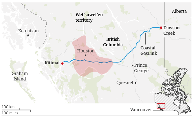
In the course of a recent study that explored news media coverage of Indigenous environmental resistance in Canada and the United States more generally, I encountered two notable examples of journalistic cartography related to the Wet’suwet’en people’s resistance to the Coastal GasLink natural gas pipeline currently under construction through their unceded territory in northern British Columbia. The maps were embedded in articles found in the US online edition of the Guardian (Dhillon and Parrish 2019) (figure 1), a left-leaning news media agency based in the United Kingdom (Jonsson 2014), and on the federally funded center-left (Brown 1996; Hopper 2015) Canadian Broadcasting Corporation’s (CBC) online news site, CBC News (2020) (figure 2).

Both maps presented in figures 1 and 2 explicitly identify Wet’suwet’en traditional territory and the proposed path of the Coastal GasLink pipeline from Dawson Creek to Kitimat, British Columbia, in addition to colonially imposed political boundaries such as the BC-Alberta interprovincial border, towns, and cities. Basic geographical features such as the Pacific Ocean, major rivers, the Rocky Mountains, and highways (in the case of the Guardian) are visible but not labeled on either map. The implication is that they are less important or irrelevant. The CBC News map (figure 2) further identifies the location of the Gidimt’en resistance camp, disproportionately represented by a large yellow square, presumably for emphasis.
The Gidimt’en camp, built directly in the proposed path of Coastal GasLink, is a central site for the self-described land defenders who support the Wet’suwet’en hereditary chiefs’ opposition to the pipeline. Although mainstream economic pundits have described the potential failure or curtailing of Coastal GasLink as a political and financial “disaster” (Mason 2020), Guardian authors Dhillon and Parrish (2019) emphasize that the hereditary chiefs and their supporters “are defending their right to protect themselves and future generations from irreparable harm” (para. 20).

Although the CBC News (2020) article’s text takes a generally educational and arguably neutral approach, in keeping with its center-left sociopolitical positioning (Hopper 2015), to inform readers of the tensions between the elected and the hereditary Wet’suwet’en leaders, the Guardian article (Dhillon and Parrish 2019) strikes a journalistic tone that is, somewhat expectedly due to its more firmly leftist orientation (Jonsson 2014), explicitly supportive of the Wet’suwet’en people’s Indigenous rights in alignment with a critical environmental justice discourse (Pellow 2018). For example, with reference to the intimidation tactics and use of force employed by the Royal Canadian Mounted Police (RCMP) to disrupt and deter Wet’suwet’en land defenders, Dhillon and Parrish (2019) suggest that “The RCMP’s suppression of Indigenous dissent against resource extraction is rooted in its founding as a paramilitary entity 150 years ago … More recently the Canadian state has thrown its national security apparatus behind oil and gas development—often directly at Indigenous people’s expense” (para. 21 and 24).
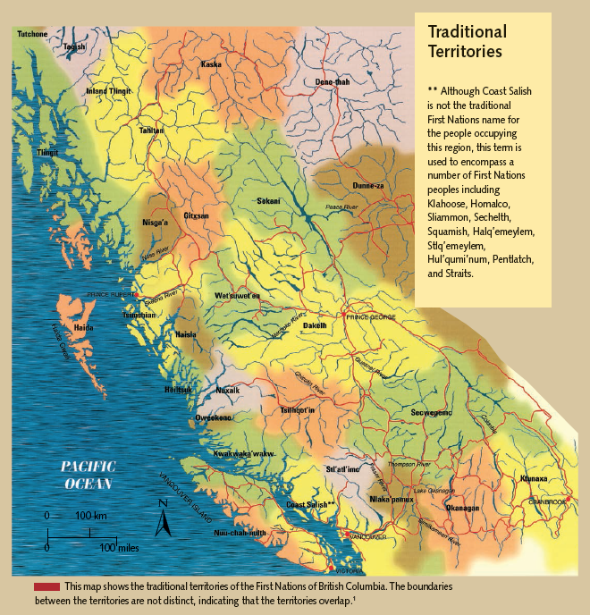
However, in both cases, despite the arguably decolonizing implicit intentions of the authors to provide their audience with enhanced critical understanding of the Coastal GasLink conflict, the associated maps as presented above further emphasize colonial geopolitical perspectives. The null curriculum is also significant: for example, rather than identifying the surrounding Indigenous territories of the Haisla, Gitxsan, Sekani, and Dakelh peoples as evident in figure 3, which is a map from a textbook published by the British Columbia Ministry of Education (Campbell, Menzies, and Peacock 2003), primarily colonial place-names for cities and towns as well as political boundaries such as the BC-Alberta interprovincial border and the northern US-Canada international border are identified. Wet’suwet’en territory is presented as though it is surrounded by exclusively colonial rather than Indigenous territories.
Moreover, in another strong example of the null curriculum at work, neither the CBC News nor the Guardian maps’ authors are identified. This absence further amplifies the maps’ anonymously assumed accuracy—we might reasonably deduce that they were copied or modified from colonial government sources or similar. Both maps also display basic topographical features, such as the Pacific coastline, prominent waterways, and mountainous areas, but neglect to portray the geographic or ecological complexity of the region in a significant manner. These types of cartographic choices deeply influence readers’ perceptions of a given case, effectively relegating such considerations to the background in favor of colonially rooted geopolitical foci; they also represent missed opportunities to critically decolonize and constructively Indigenize journalistic maps. Would the potentially disastrous consequences of an oil pipeline spill or a gas pipeline leak be taken more seriously by the broader public if complex and interconnected ecological and Indigenous cultural perspectives were more prominently featured in stories of this nature?

In contrast, the BC First Nations map presented in figure 3, which is drawn from a provincially mandated First Nations studies textbook (Campbell, Menzies, and Peacock 2003), promotes decolonized understanding and provides explicitly Indigenized cultural and territorial information. Indigenous territories are identified in bold with colonial place-names deemphasized in lighter background text. We are also presented with a much more detailed view of prominent rivers and associated tributaries. This allows us to quickly identify the association of a given cultural group with a particular river and/or broader watershed; it adds a more specific geographical and ecological layer to an otherwise predominantly geopolitical map. Also notable is the insightful caption at the bottom regarding the overlap of Indigenous territories. This caption holds important educational implications as many First Nations traditionally viewed border regions as shared spaces with neighboring groups; this concept persists in the present day and is particularly relevant for treaty and land use negotiations (Sletto 2009; Tobias 2009).
What would journalistic maps teach us if they consistently showed Indigenous territories and place-names (Carter 2005; Kingston 2009) such as those presented in figure 3 along with more specific geographical and/or ecological features rather than a preponderance of Western political boundaries? Further insights can be gained through consideration of historical and contemporary Indigenous cartographic practices.
Indigenous Cartography: Mapping Back
Indigenous people across Turtle Island / North America have both visual (Binnema 2001) and oral (Brody 1998) mapping traditions that do not commonly align with Western cartographic paradigms and practices. Building upon foundational colonial concepts such as terra nullius (Tuck, McKenzie, and McCoy 2014), vacuum domicilium (Corcoran 2018), and manifest destiny (Calderon 2014) that mandated unfettered European and Euro-North American colonial expansion and settlement, these differences were and continue to be exploited by colonial powers to ignore and/or erase Indigenous cartographies and associated land use governance and practices (Berger 2009; Rivard 2008).
For example, Binnema (2001) relates the confusion that arose when Euro-American explorers Lewis and Clark attempted to use a Blackfoot map to navigate the eastern slopes and foothills of the Rocky Mountains in present-day Alberta and Montana. Lewis and Clark neglected to realize that the Blackfoot map used the mistakis—the western horizon line or “backbone” of the Rockies when viewed from the eastern side—as its central orienting feature. A mistakis-centered orientation differs from the east-west continental divide—the somewhat meandering north-south line of demarcation for water flowing east to the Atlantic Ocean (or north to the Arctic) and west to the Pacific—commonly employed by Western cartographers for mapping the Rockies but much more difficult to ascertain when viewed in situ from the eastern plains or foothills. As Binnema emphasizes, “Blackfoot maps were designed by a plains people and they truly represent a view … from the plains” (p. 212). This use of the mistakis should make perfect sense to anyone who is familiar with the eastern slopes, foothills, and plains. I think of it every evening when I gaze to the west from my home in Moh’kins’tis/Calgary as the sun sets over the Rockies. This is also a compelling example of the deeply place-based understanding of particular territories inherent within Indigenous cultures (Cajete 1994) that does not often correlate with Western assumptions and practices, cartographic or otherwise (Cajete 1994; Little Bear 2000).
In another illuminating historical example, Rivard (2008) describes the Canadian government’s cartographic imposition of new property boundaries, rail lines, pathways, roads, and place-names in an effort to attract European settlers to the Red River region of southern Manitoba in the mid- to late nineteenth century. This map-based insurgence was bolstered by the increasing presence of the North-West Mounted Police (NWMP)(Nettelbeck and Smandych 2010)—the precursor of the RCMP—and intentionally ignored the long established and more equitable river lot system common to Métis communities in the present-day prairie provinces of Alberta, Saskatchewan, and Manitoba. River lots were typically long, narrow strips of land leading down to a common riverfront on one side (Rivard 2008). This system allowed several families to access a consistent water source in the same space that only one family might use in a wider lot system such as those imposed by the NWMP on behalf of the Canadian government and the incoming settlers. These actions resulted in significant displacement, losses of land, and water access for Métis people and precipitated subsequent armed resistance as well as legal and political negotiations between the Métis and Canadian governments that resulted in the formation of the province of Manitoba in 1870 (Rivard 2008) and a successful modern-day land claim by the Manitoba Métis Federation (Poitras 2018).
Mapping back
Despite such challenges—the ramifications of which persist to the present day—Indigenous people have been steadily resisting colonial cartography through various media, most recently digital, to decolonize, Indigenize, reclaim, and re-story contemporary understandings of Indigenous geographies and associated encroachment upon and degradation of Indigenous lands and waterways (Caquard et al. 2019; Hunt and Stevenson 2017; Kidd 2019).
Variously termed “guerilla cartography” (https://www.guerrillacartography.org), “mapping back” (http://mappingback.org), or “counter-mapping” (Hunt and Stevenson 2017), such practices range from more common decolonizing interventions that document socioecological injustices and associated activism by superimposing Indigenous place-names and other political, cultural, or ecological markers on Western-style maps (https://ejatlas.org; https://native-land.ca) to less common Indigenized “communocentric” maps (Roy 2007) that disregard or diverge from Western cartographic practices in favor of more locally and culturally relevant representations. Others, as illustrated by figure 4 bring together both Western and communocentric cartographic practices.

Often embedded within “trans-media assemblages” (Kidd 2019, pp. 963–964) that may also include music, photographs, and videos, the digital sphere allows Indigenous and allied activists to quickly and directly share countermaps and other media with each other as well as with the colonial governments and industrial groups under scrutiny in a given case. As such, transmedia assemblages serve to not only digitally document and raise awareness of socioecological disasters but also assist resistance organizers in their coordination efforts.
Countermaps have featured prominently in recent Indigenous environmental media campaigns such as the Secwepemc people’s resistance to the Trans Mountain Pipeline in southern British Columbia (Kidd 2019). The Secwepemc have utilized global positioning systems (GPS) and Western-style digital maps to coordinate the establishment of a series of “tiny house” (Kidd 2019) resistance camps along the proposed route of the pipeline and document the associated arrests of land defenders in a manner easily understandable to those familiar with Western cartographic practices (http://www.tinyhousewarriors.com/wp-content/uploads/2020/11/Arrests.pdf).
Participatory mapping to support both general and specific manifestations of Indigenous and allied environmental resistance is rapidly rising in popularity and practice (Salovaara 2016; Sletto 2009). For example, as an undergraduate student at the University of British Columbia (UBC), Andrew Barton created an interactive, participatory GeoLive map that allowed people to upload text, images, and video narratives along the proposed route of the Northern Gateway Pipeline to support resistance efforts (Marck 2014). Due, in part, to such efforts by Indigenous and allied activists, Northern Gateway failed to gain unequivocal Indigenous community support (Wood and Rossiter 2017), widespread social license, or federal governmental approval without significant conditions (Bowles and MacPhail 2017). In the end, it was effectively canceled by a federal government ban on oil tanker traffic along the Pacific coastline adjacent to its proposed terminus at Kitimat, British Columbia (Tasker 2018).
Collectives of Indigenous and allied cartographers have also been engaging in participatory initiatives that produce and catalogue maps that support and increase awareness of Indigenous territories and contemporary sovereignty and resistance movements (Caquard et al. 2019). Collaboratively governed participatory websites such as https://native-land.ca/; http://mappingback.org; and https://www.guerrillacartography.org allow Indigenous and allied cartographers and activists to create, share, and archive historical and contemporary maps in the service of Indigenous land and environmental justice efforts.
Inspiring countermapping collections have also been brought together in edited books such as This Is Not an Atlas, by the Kollektiv Orangotango+ (2019). One example from this compilation is depicted in figure 4. This map was developed through a participatory “situational” mapping process with Indigenous peoples from the Beija-Flor community, Preto de Eva River in the Amazonas region of Brazil, through collaboration with the Projeto Nova Cartografia Social da Amazônia, a cartography collective (de Almeida, Dourado, and Bertolini 2019, 48). Their intention was to visually document local land use, environmental practices, and social relationships as part of a successful effort to expropriate and protect land from the adjacent municipality (de Almeida, Dourado, and Bertolini 2019).
The map in figure 4 brings together Western cartographic practices with communocentric Indigenous ontological elements. For example, a Google Earth satellite base map, a Western-style legend, and associated notations are juxtaposed with the green and yellow inset in the bottom left corner that depicts a “Social Relations Area” that provides details regarding the locations, relationships between, land and environmental practices of, and routes and paths used by Indigenous groups in the broader region (Beija Flor II and III) beyond the community under focus in figure 4, which is identified as “Beija-Flor I.” As such, this map is a strong example of both decolonizing and Indigenizing cartographic practices—it simultaneously engages critically with Western cartographic practices and introduces Indigenous ontological elements such as the relational, cultural, and ecological interdependence of Beija-Flor I with neighboring Indigenous communities.
The intersection of Indigenous communities’ social and environmental concerns related to extractive industry “man camps” has also been cartographically documented. Cheyenne scholar Annita Hetoevėhotohke’e Lucchesi leads the Sovereign Bodies Institute, which maintains a database of Missing and Murdered Indigenous Women and Girls (MMIWG) in the United States (https://www.sovereign-bodies.org). Associated publications document the connections between gendered violence, colonial land dispossession, and extractive industries through written text and cartography (e.g., Sovereign Bodies Institute and Brave Heart Society 2019; Lucchesi 2019). Such fora provide spaces for Indigenous people and allies to present counternarratives (Giroux et al. 2013) that challenge dominant colonial and utilitarian (Varzari 2001) discourses regarding natural resource development, gender, and Indigeneity (Awasis 2014; Weber, Geigle, and Barkdull 2014). They offer visual and textual evidence of existing and potential socioecological disasters that result from such activities—crucial details that are often ignored or deemphasized by mainstream media (Stiegman and Pictou 2010).
Traditional land use studies (TLUS)
Digital mapping is also a core component in traditional land use studies (TLUS)—a well-established process within which traditional and contemporary Indigenous practices and knowledge within a given territory are documented (Natcher 2001; Robinson and Ross 1997; Tobias 2009). TLUS typically involve a combination of recorded individual or collective oral interviews, participatory mapping sessions, and time spent on the land with Elders, other traditional knowledge holders, and contemporary users of land and waterways for activities such as fishing, hunting, gathering berries or firewood, travel, and spiritual practices, among others.
TLUS have grown from their origins in topographical base maps that were subsequently overlaid with several layers of transparencies for the various activities described above to contemporary multilayered digital formats (Tobias 2009). This allows users to access particular sets of data individually or collectively; it also facilitates the protection of sensitive cultural and spiritual knowledge that a given community may not want publicly shared in the course of, for example, a land rights court case. Both public and community-specific educational opportunities are inherent within such repositories.
Beginning with early cases such as the Berger Inquiry in the 1970s into the potential socioecological impacts of oil and gas development in the Mackenzie River valley watershed in northern Canada (Natcher 2001), examples of the successful use of TLUS maps to support Indigenous communities in treaty and land use negotiations have emerged across Turtle Island / North America and elsewhere (Tobias 2009). Whether for activist, resource negotiation, treaty, or journalistic purposes, the creation of credible and reliable maps requires significant time, capacity, and dedication (Holmberg and Foote 2008; Kidd 2019).
Mapping Indigenous environmental initiatives
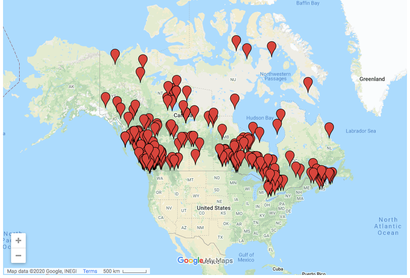
Digital maps are also increasingly used to document environmentally related Indigenous developments. For example, I led a small team that mapped renewable energy projects in various stages of development taking place in Indigenous communities across Canada from 2014 to 2016 (Lowan-Trudeau 2017, 2019). Commonly motivated by a combined interest in replacing diesel generators or other grid-derived, fossil fuel–based electrical sources to mitigate associated pollution and climate change, and the potential for increased economic and environmental sovereignty, Indigenous communities have become leaders in renewable energy development in Canada, the United States (Lockett 2020), and elsewhere (Bargh 2010). Some projects, such as the Standing Rock Sioux’s solar initiative, are developed in direct response to the incursion of oil and gas pipelines through or close to their territory as a constructive form of resistance (Nobel 2019).
As displayed in figure 5, we used an interactive Google Map to document every community-based development that we identified in Canada. This allowed us to show patterns; for example, a higher number of developments in the provinces of British Columbia on the Pacific coast and Ontario in central Canada. Clicking on a given red pinpoint reveals project-specific information such as the type of renewable energy (e.g., solar, wind), funding, and time frame of the project.

Keeping in mind the general issues raised earlier, one self-critique that I would put forth in this case is our lack of explicit recognition of Indigenous territories. Although community names are associated with a given red pinpoint as a matter of course, due to lack of critical foresight and advanced training in digital cartography, we relied upon the colonially imposed provincial and international borders provided by default in Google Maps to demarcate each cartographic region. This was a missed opportunity on our part to both decolonize and Indigenize our cartographic representation of Indigenous renewable energy initiatives and associated territories. This map could have been enhanced, for example, through creative font use to identify Indigenous regions alongside colonial geographic terms as presented on the BC First Nations map (figure 3). Other possibilities include juxtaposing it with a similar map showing Indigenous rather than Canadian political and cultural boundaries and regions or digitally layering the map in a more comprehensive manner that shows both colonial and Indigenous demarcations.
This project generated a significant amount of media, government, industry, community, policy, and research interest. I was surprised to receive numerous requests for comment, additional details, and information regarding my plans for future research. I think that this level of response is representative of the potential power of digital countermapping practices. Although the data and supporting details for this project were exclusively drawn from publicly available government, news media, and community websites, they hadn’t been synthesized anywhere else in this manner at that point. Despite the map’s imperfections, bringing together a large amount of data in this geospatial format allowed us to visually represent the socioecological trend of Indigenous communities becoming leaders in renewable energy development across Canada. This proved to be appealing to the various parties mentioned above. For example, it provided journalists in both mainstream (Ireland 2016) and independent (Leahy 2017; Wilt 2018) media contexts and others in policy, nonprofit, and community settings (e.g., Cameron and Wetchie 2018) with a credible source to support related stories and further research that documented and/or celebrated this trend. Collectively considered, these research, media, and policy-related actions hold the potential to increase both public and government awareness of and support for current and future countermapping initiatives.
Future Possibilities
Along with a rise in Indigenous journalism across Turtle Island / North America (Brady and Kelly 2017) and elsewhere (Hanusch 2013), a growing number of non-Indigenous media outlets and publishers are striving to create culturally responsive and Indigenized digital fora. For example, UBC Press and the University of Washington Press recently collaborated to create RavenSpace (https://ravenspacepublishing.org/about-us/), an online publishing site that allows for the use of interactive digital media to share Indigenous knowledge and perspectives. Cartographic collectives such as mappingback.org and consultants such as the Firelight Group (https://www.indigenousmaps.com) also host workshops to share their skills and experiences with others.
Rather than using conventional maps based on colonial borders and epistemologies, media outlets would better serve decolonization, Indigenization, and social and environmental justice more generally by replacing them, or at least juxtaposing or superimposing them, with maps that explicitly and consistently show Indigenous territories and place-names, especially in articles directly related to Indigenous topics.
Advances in digital cartography afford opportunities for journalists to share or create online fora that facilitate participatory mapping (Shemak 2014) to serve the interests of social, health, and environmental well-being and justice (Salovaara 2016). For example, news agencies could host sites that allow users to upload narratives and images related to acute or ongoing socioecological crises. Such possibilities build upon related participatory media initiatives more broadly that include, for example, involving Indigenous youth in environmentally linked documentary productions relevant to their home communities (MacKenzie and Stenport 2020).
News media organizations would also be well advised to provide increased funding and training for, and explicit acknowledgment of, advanced and critically oriented cartographic practices.
Considering the omnipresent constraints of time, training, and finances (Holmberg and Foote 2008), another related consideration is the type of digital mapping software that is employed. Media groups must consider if it is adequate to use easily accessible but arguably less sophisticated Big Tech platforms such as Google Maps or preferable to train or contract staff that are able to use more advanced cartographic software. Similar to traditional land use studies (TLUS), questions of Indigenous ownership of and control over certain types of traditional knowledge may also arise in such endeavors and, as such, liaising with appropriate community-connected experts may be required.
As Parks and Walker (2020) emphasize, news media become particularly important and influential in crisis situations to significantly influence not only public opinion and understanding but also associated short- and long-term governmental intervention and relief responses or lack thereof. As such, news media hold the power to either reinforce or disrupt societal inequities and, in cases of Indigenous socioecological disaster, support either the colonially motivated destruction or community-led preservation and resurgence of land- and water-based Indigenous cultures.
News media could also serve social and environmental justice interests by regularly highlighting and including the innovative efforts of Indigenous and allied cartographers in general and specific instances of mapping socioecological disaster. Associated research into the influence of journalistic maps on public perceptions of critical Indigenous socioecological issues would prove illuminating.
Consideration of and support for the efforts and possibilities described above will contribute to not only the decolonization (Smith 2013) but also Indigenization (Battiste 2016) of news media generally and journalistic cartography in particular. Critical shifts in this direction will lead to a more critically informed public and raise Indigenous voices and perspectives in a spirit of social and environmental justice.
Transparency Statement
There are no competing interests related to this manuscript.
Acknowledgments
This inquiry was made possible, in part, through funding from Fulbright Canada’s Visiting Research Chair program (UC Santa Barbara, Environmental Studies, 2019–20).